 Southern Interior - Hwy 23
Mica Dam - N
Highway 23 at Mica Dam about 152 km north of Revelstoke, looking north.
Mica Dam - S
Highway 23 at Mica Dam about 152 km north of Revelstoke, looking south.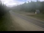
50-Mile
Highway 23 about 90 km north of Revelstoke, looking north.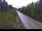
Blanket Creek - N
Highway 23 about 30 km south of Revelstoke and 22 km north of Shelter Bay Ferry, looking north.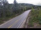
Blanket Creek - S
Highway 23 about 30 km south of Revelstoke and 22 km north of Shelter Bay Ferry, looking south.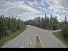
Shelter Bay - End
Highway 23 near the Upper Arrow Lake ferry landing at Shelter Bay, end of queue, looking north.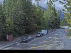
Shelter Bay - Lineup
Highway 23 near the Upper Arrow Lake ferry landing at Shelter Bay, looking north at lineup.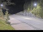
Shelter Bay - Ferry Ramp
Highway 23 near the Upper Arrow Lake ferry landing at Shelter Bay, looking south at terminal ramp.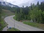
Galena Bay Landing - End
Highway 23 near the Upper Arrow Lake ferry landing at Galena Bay, looking at end of lineup.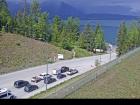
Galena Bay Landing - Front
Highway 23 near the Upper Arrow Lake ferry landing at Galena Bay, looking at front of lineup.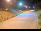
Galena Bay Landing - Lineup
Highway 23, at the bottom of the Upper Arrow Lake ferry landing at Galena Bay, looking at lineup.
Galena Bay Landing - Ferry Ramp
Highway 23, at the bottom of the Upper Arrow Lake ferry landing at Galena Bay, looking at ferry boarding.


